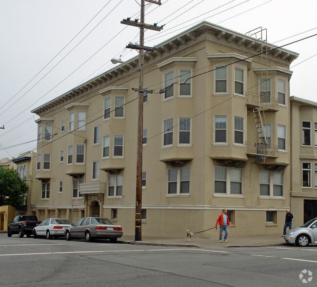
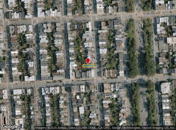
Property Record
275 15Th Ave, San Francisco, CA 94118
NEARBY LISTINGS FOR SALE OR LEASE
Property Detail
275 15Th Ave
San Francisco
Outside Land Bl 167
San Francisco-Redwood City-South San Francisco, CA
San Francisco
1418-016
California
Sfr
0.07 AC
2,125 SF
Richmond District
DEMOGRAPHICS near 275 15Th Ave
1 Mile
3 Mile
5 Mile
2024 Total Population
51,049
317,818
707,651
2029 Population
47,489
294,153
655,998
Pop Growth 2024-2029
(6.97%)
(7.45%)
(7.30%)
Average Age
43
43
43
2024 Total Households
21,516
141,956
313,222
HH Growth 2024-2029
(7.51%)
(7.92%)
(7.68%)
Median Household Inc
$131,557
$144,528
$130,387
Avg Household Size
2.30
2.10
2.10
2024 Avg HH Vehicles
1.00
1.00
1.00
Median Home Value
$1,123,017
$1,116,163
$1,107,374
Median Year Built
1947
1947
1948
Nearby Places
Map Layers
Map Styles
 Street
 Aerial
- Restaurants
- Banks
- Shops
- Fitness
- Groceries
PUBLIC TRANSPORTATION
COMMUTER RAIL
San Francisco 4Th & King (Caltrain - Caltrain (Caltrain))
DRIVE
WALK
Distance
San Francisco 4Th & King (Caltrain - Caltrain (Caltrain))
13 min
6.2 mi
San Francisco Caltrain Station Southbound (Express - Caltrain (Caltrain), Limited - Caltrain (Caltrain), Local Weekday - Caltrain (Caltrain), Local Weekend - Caltrain (Caltrain))
DRIVE
WALK
Distance
San Francisco Caltrain Station Southbound (Express - Caltrain (Caltrain), Limited - Caltrain (Caltrain), Local Weekday - Caltrain (Caltrain), Local Weekend - Caltrain (Caltrain))
13 min
6.3 mi
AIRPORT
San Francisco International
DRIVE
WALK
Distance
San Francisco International
29 min
17.2 mi
Metro Oakland International
DRIVE
WALK
Distance
Metro Oakland International
39 min
23.1 mi
Freight Ports
Port of San Francisco
DRIVE
WALK
Distance
Port of San Francisco
11 min
5.0 mi
SALE & LEASE HISTORY
LISTING DATE
SALE/LEASE

Apr 01, 2021
For Sale
Nearby Properties
Address
Land Use
TOTAL SIZE
Lot Size
Zoning
Address
Land Use
TOTAL SIZE
Lot Size
Zoning
1,015,000 SF
2.43 AC
RC4
Address
Land Use
TOTAL SIZE
Lot Size
Zoning
718 SF
18.55 AC
RH2
Address
Land Use
TOTAL SIZE
Lot Size
Zoning
246,069 SF
0.69 AC
Address
Land Use
TOTAL SIZE
Lot Size
Zoning
89,551 SF
0.73 AC
RC4
Address
Land Use
TOTAL SIZE
Lot Size
Zoning
409,895 SF
7.20 AC
RH3
Address
Land Use
TOTAL SIZE
Lot Size
Zoning
524,271 SF
1.06 AC
RC4
Address
Land Use
TOTAL SIZE
Lot Size
Zoning
2.40 AC
NC3
Address
Land Use
TOTAL SIZE
Lot Size
Zoning
250,843 SF
6.62 AC
NC3
Address
Land Use
TOTAL SIZE
Lot Size
Zoning
1.68 AC
RM2
Address
Land Use
TOTAL SIZE
Lot Size
Zoning
17.91 AC
RH-2
Address
Land Use
TOTAL SIZE
Lot Size
Zoning
126,849 SF
0.60 AC
CM
Address
Land Use
TOTAL SIZE
Lot Size
Zoning
420,000 SF
0.79 AC
NC-3
Address
Land Use
TOTAL SIZE
Lot Size
Zoning
1.14 AC
P
Address
Land Use
TOTAL SIZE
Lot Size
Zoning
106,602 SF
0.50 AC
RC4
Address
Land Use
TOTAL SIZE
Lot Size
Zoning
4.41 AC
RH-3/RM-2
Address
Land Use
TOTAL SIZE
Lot Size
Zoning
905,491 SF
10.27 AC
RM1
Address
Land Use
TOTAL SIZE
Lot Size
Zoning
230,310 SF
0.65 AC
NC3
Address
Land Use
TOTAL SIZE
Lot Size
Zoning
140,380 SF
0.53 AC
NC3
Address
Land Use
TOTAL SIZE
Lot Size
Zoning
243,376 SF
0.69 AC
Address
Land Use
TOTAL SIZE
Lot Size
Zoning
73,000 SF
0.40 AC
C-3-G
Address
Land Use
TOTAL SIZE
Lot Size
Zoning
141,397 SF
0.88 AC
RM-4
Address
Land Use
TOTAL SIZE
Lot Size
Zoning
2.24 AC
RM3
Address
Land Use
TOTAL SIZE
Lot Size
Zoning
0.29 AC
RM4
Address
Land Use
TOTAL SIZE
Lot Size
Zoning
36,522 SF
0.38 AC
HAYES
Address
Land Use
TOTAL SIZE
Lot Size
Zoning
75,989 SF
0.72 AC
Address
Land Use
TOTAL SIZE
Lot Size
Zoning
116,000 SF
0.38 AC
RC4
Address
Land Use
TOTAL SIZE
Lot Size
Zoning
90,539 SF
2.28 AC
RH2
Address
Land Use
TOTAL SIZE
Lot Size
Zoning
95,303 SF
0.30 AC
RC4
Address
Land Use
TOTAL SIZE
Lot Size
Zoning
14,525 SF
0.46 AC
NC2
Address
Land Use
TOTAL SIZE
Lot Size
Zoning
107,588 SF
1.04 AC
RM1
The World's #1 Commercial Real Estate Marketplace
Connect with us
© 2025 CoStar Group
The information above has been obtained from sources believed reliable. While we do not doubt its accuracy we have not verified it and make no guarantee, warranty or representation about it. It is your responsibility to independently confirm its accuracy and completeness. Any projections, opinions, assumptions, or estimates used are for example only and do not represent the current or future performance of the property. The value of this transaction to you depends on tax and other factors which should be evaluated by your tax, financial, and legal advisors. You and your advisors should conduct a careful, independent investigation of the property to determine to your satisfaction the suitability of the property for your needs.